This is part 1 of a two-part series concerning Richard Condrey and Natalie Peyronnin’s recent paper, “Using Louisiana’s coastal history to innovate its coastal future,” published in Shore & Beach, Fall 2017. See part 2 here.
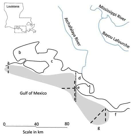
They were there, billions of oysters on the Great Barrier Reef of the Americas (GRBA), along the southern coast of Louisiana – a dangerous impediment to navigation. Just three to four feet under the surface of the water, though visible when the winds blew from the north, with only narrow and intricate channels along a nearly continuous coast with passage only for pirogues.
They were there in 1492, when Columbus sailed into his New World. They bathed in the nutrient and oxygen-rich waters of the Gulf of Mexico, sweetened by subsurface and surface freshwater discharges of the Mississippi River Basin – continuing the efforts of uncounted generations of oysters to create and maintain a vast marine ecosystem, while protecting a majestic, growing delta.
Estimated extent of the Great Barrier Reef of the Americas (GBRA, gray area) in 1785–1807 based on the surveys conducted by Evia (1968, dashed lines) and Dumain (1807, dotted line) and the consistency […]
Full article: The Great Barrier Reef of the Americas: Coastal Lessons from the Past
More about the Coastal Master Plan and Louisiana coastal restoration solutions:
Explore the Largest Coastal Restoration Project Completed In Louisiana’s History
Louisiana Legislature Approves 2017 Coastal Master Plan
Mississippi River Sediment Diversions & Louisiana
Louisiana floods: Tool Lets You See Flood Risk to Your Home
How Can We Create a Sustainable Future for South Louisiana, Navigation and Other Industries?


